Hiking holiday in the Salzburg region
Set off into the surrounding mountains straight from the Gut Weissenhof hiking hotel in the Salzburg region. Nestled between the Dachstein in the north and the Radstädter Tauern in the south, the Salzburg region offers gentle alpine hikes, scenic summit treks and peaceful spots in the great outdoors.
Hiking and climbing around Radstadt
Radstadt is the ideal starting point for your hiking holiday in the Salzburg region. A well-developed network of signposted hiking trails leads through alpine meadows and forests and up to scenic peaks. Families enjoy easy tours with gentle ascents, and the region also offers ideal conditions for anyone looking for sporting challenges while hiking in the Salzburg mountains.
In addition, around the Dachstein you will find well-secured via ferratas, alpine trails and striking rock formations that provide varied mountain experiences, from first attempts on the rock to more demanding tours.
We’d be happy to advise you in person at reception on suitable walks, current conditions and personalised recommendations for your walking holiday in the area around the Gut Weissenhof walking hotel.

Our in-house hike
Guided hike
With Erich to his favourite spots
Every week it’s time to pack your backpack and go hiking together. Together with Erich, whom many guests know and appreciate from the bar, you head out to his favourite spots. He has been part of our team for many years and also loves being out in the mountains. He knows the most beautiful paths, the alpine flowers and the places with the best views.
In the morning, you travel together on the Weissenhof buses to the starting point of the hike. Along the way, there is often a stop at a mountain hut, with time for refreshments, conversation and relaxed time together.
In the afternoon, you return to Gut Weissenhof with wonderful memories, shared moments and perhaps one or two new acquaintances.
Hiking around the Weissenhofalm
Our own Weissenhofalm – Hintergnadenalm – is also a starting point for numerous hikes into the surrounding mountains. From here, trails lead to the Johannes Waterfall, to neighbouring alpine pastures and further up to scenic peaks.
The alpine pasture is also located along the children’s themed trail “Alles-Alm”. This connects several alpine pastures of the Gnadenalm and, at various stations, shares interesting facts about alpine farming, the landscape and the lives of the animals. With a bit of luck, you may also meet our oxen along the way, as they spend the summer up here.
On our in-house hike with Erich, you may also head up to our own alpine pasture, where a hearty snack awaits after the hike.

Bus to the start of your hike
Getting around in the mountains
Flexible travel in the Salzburger Sportwelt
If you prefer not to travel by your own car, you will find a convenient alternative in Radstadt and the Salzburger Sportwelt. With the Guest Mobility Ticket, you can use public bus services free of charge and easily reach numerous starting points for your hikes.
A special option is the dedicated hiking bus to the Roßbrand. It takes you directly to our local mountain, ideal for families, walkers, or anyone who would like to enjoy the panoramic trail at a relaxed pace. From the stop, it is only about 20 minutes to the Radstädter Hütte and the summit.


Hikes around Gut Weissenhof
The region around Radstadt offers a wide variety of hiking trails for every level. The tours presented here are a selection of our recommendations. You can receive further tips and individual suggestions at any time in person at reception.

Hiking tips
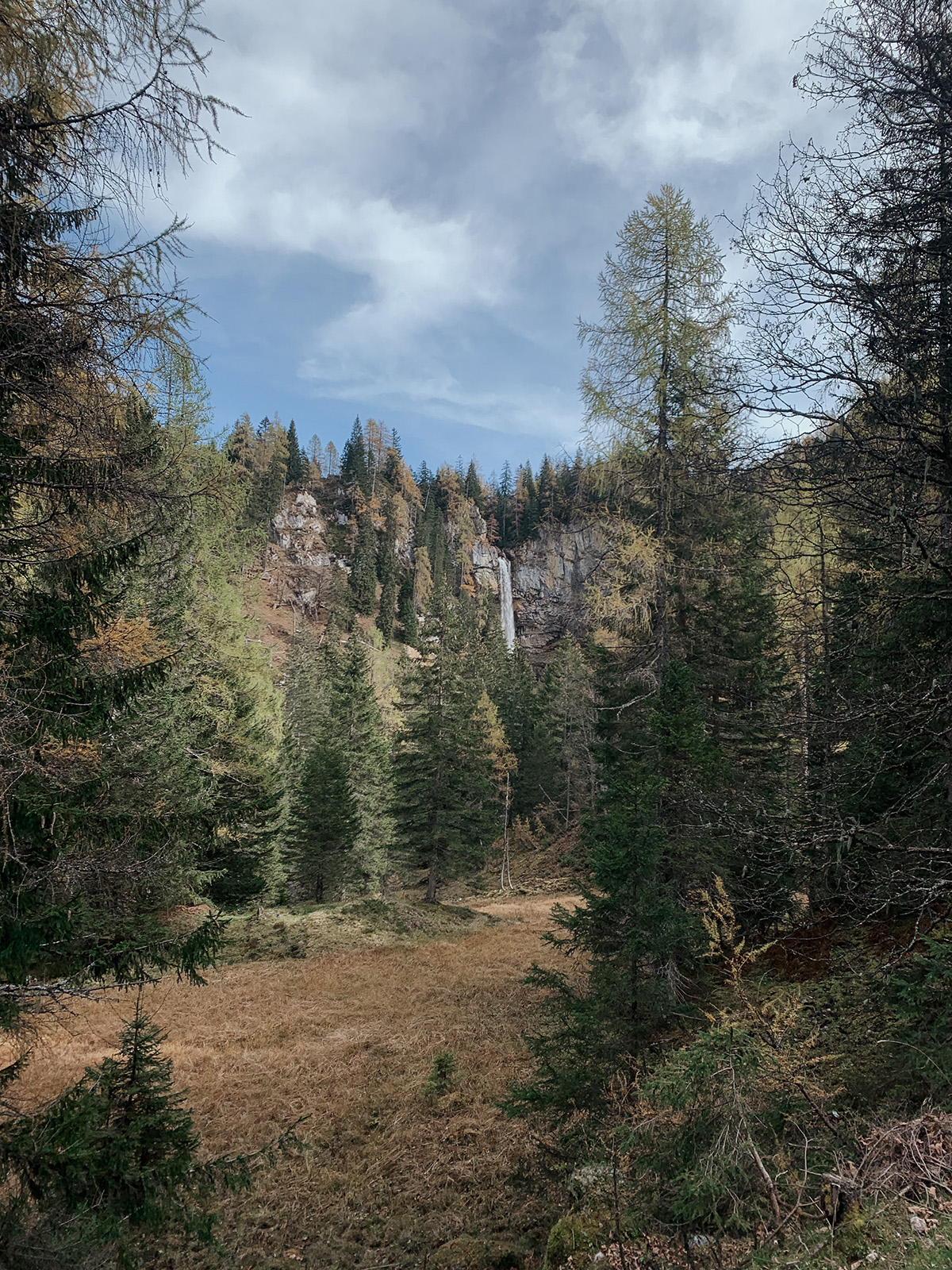
Johannes Waterfall – starting point Weissenhofalm | Easy
Short hike to a natural highlight
From the Weissenhofalm starting point, a well-marked trail leads to the Johannes Waterfall in around 25 minutes. The route runs through forest and alpine pasture terrain and is ideal for a short, leisurely hike.
Tour details
Duration: approx. 50 minutes (out and back)
Difficulty: Easy
Type: forest and alpine pasture trail
Starting point: Hintergnadenalm (approx. 1,336 m)
Brief route description
Well-maintained, signposted hiking trail with a gentle ascent. The path leads through shady forest and across mountain meadows to the waterfall.
-> You can obtain a detailed description of the hike and a hiking map at reception
What to expect
• Johannes Waterfall as a natural highlight
• Short, easy-to-manage tour
• Alpine rose bloom in midsummer
• Quiet, unspoilt landscape
• Refreshment stop at the Hintergnadenalm
Jägersee | Easy
Idyllic mountain lake at the end of the valley
Jägersee lies at the end of the Kleinarler Valley and is one of the most beautiful mountain lakes in the region. The circular trail around the lake is flat, easy to walk and ideal for a leisurely hike with views of the surrounding mountains.
Tour details
Duration: approx. 1 hour
Difficulty: Easy
Type: circular lake trail
Starting point: Jägersee car park
Distance from Gut Weissenhof: approx. 30 km
Brief route description
The circular trail around Jägersee follows easy-to-walk, mostly level paths along the shore. The path is wide, mostly shaded and technically easy. A few gentle ascents and descents add variety, while remaining very manageable.
-> You can obtain a detailed description of the hike and a hiking map at reception
What to expect
• Flat circular trail
• Views of the surrounding peaks
• Ideal for families
• Refreshment options
• Nature and landscape conservation area
Sonnenalm | Easy
Short alpine pasture hike with views
The Sonnenalm is a cosy hiking destination above Pichl near Schladming. You can reach the hut in around 50 minutes via an easy-to-walk path through the forest and across open meadows—ideal for a relaxed half-day hike.
Tour details
Duration: approx. 50 minutes (one way)
Difficulty: Easy
Type: forest and meadow trail
Starting point: Vorberg/Ramsau car park/Pension Arnika
Drive from Gut Weissenhof towards Schladming; in Pichl, turn right towards Vorberg/Ramsau.
Brief route description
From the car park, a wide gravel path leads through the forest. The ascent is steady and easy to manage. Shortly before the destination, the terrain opens up with beautiful views of the surrounding mountains.
-> You can obtain a detailed description of the hike and a hiking map at reception
What to expect
• Short, easy-to-manage alpine pasture hike
• Ideal for families or as an afternoon destination
• Refreshment stop at the Sonnenalm
• Views of the Schladming mountains
Bürgerberg – directly from Gut Weissenhof | Moderate
Panoramic trail with an alpine hut destination from the hotel
This varied hike starts right at the hotel and leads up to the Bürgerberghütte. The steady ascent is rewarded with beautiful views of Radstadt and the surrounding mountains. Ideal for anyone who would like a sporty half-day hike without having to drive.
Tour details
Duration: approx. 3 hours
Difficulty: Moderate
Type: forest and alpine pasture hike
Start: directly at Gut Weissenhof
Return: circular route or same way back
Brief route description
From the hotel, you first head towards Radstadt and then continue uphill on well-marked trails. The route leads through forest sections and across open alpine pastures with a steady, but easy-to-walk ascent. Shortly before the destination, the views open up over the Enns Valley.
-> You can obtain a detailed description of the hike and a map at reception
What to expect
• Start directly at the hotel
• Steady ascent with a training effect
• Beautiful views of Radstadt
• Refreshment stop at the Bürgerberghütte
• Ideal as a half-day hike
Hirschwandsteig – starting point Weissenhofalm | Moderate
Alpine pasture hike with waterfall and panorama
This varied circular hike leads from the Weissenhofalm via the Ennslehenhütte and the Hirschwandsteig to the Felseralm and on to the Johannes Waterfall. A classic alpine pasture hike with impressive views, cosy refreshment stops and diverse scenery.
Tour details
Duration: approx. 3.5 hours
Difficulty: Moderate/high-level trail
Highest point: 1,800 m
Type: circular hike on alpine pasture and mountain trails
Start: Hintergnadenalm (approx. 1,336 m)
Brief route description
From the Hintergnadenalm, the trail climbs steadily uphill towards the Hirschwandsteig. A short section is secured with a steel cable. Continue across alpine pasture terrain and marked paths to the Johannes Waterfall. The route then passes the Ennslehenhütte and returns to the Hintergnadenalm.
-> You can obtain a detailed description of the hike and a hiking map at reception
What to expect
• Johannes Waterfall as a natural highlight
• Varied alpine pasture and mountain landscape
• Short secured high-level section on the Hirschwandsteig
• Refreshment stop at the Ennslehenhütte
• Alpine roses in bloom in summer
Tappenkarsee from Jägersee | Moderate
High-alpine lake in an impressive setting
From Jägersee, this varied mountain hike leads up to Tappenkarsee—one of the highest mountain lakes in the Eastern Alps. Surrounded by alpine scenery, a wide basin opens up here with an impressive mountain backdrop.
Tour details
Duration: approx. 4–5 hours
Difficulty: Moderate
Type: mountain hike with ascent
Starting point: Jägersee car park
Brief route description
At first, the trail follows a wide forest road to the Schwabalm. After that, a well-marked mountain path continues uphill at a moderate gradient to the lake. The ascent is steady and manageable, but requires good fitness.
-> You can obtain a detailed description of the hike and a hiking map at reception
What to expect
• High-alpine mountain lake
• Wide alpine landscape
• Refreshment options along the route
• Combination of forest and mountain sections
• Popular destination for sporty hikers
Forstau – Oberhüttensee & Vögeialm | Moderate
Mountain hike with lake and gorge
The hiking area around Forstau offers a wide range of options, from easy alpine pasture paths to the scenic tour to Oberhüttensee. Particularly appealing is the combination of alpine pastures, streams and the gorge, which gives the route its varied character.
Tour details
Duration: approx. 2 hours to Oberhüttensee
Duration: approx. 4 hours as a circular route via the gorge
Difficulty: Moderate
Type: alpine pasture and mountain hike
Starting point: Forstauwinkl/Vögeialm
Brief route description
From the Vögeialm, the paths lead left via the forest road or right via a trail to the Oberhütte at Oberhüttensee. The section through the gorge is a little more demanding and requires sure-footedness in places. The ascent to the lake is steady and manageable.
-> You can obtain a detailed description of the hike and a hiking map at reception
What to expect
• Oberhüttensee as a natural highlight
• Oberhütte as a refreshment stop
• Hike along streams
• Varied gorge section
• Combination of leisurely and mountain tour
Roßbrand | Moderate to Challenging
Summit tour with far-reaching views
Roßbrand is one of the most beautiful viewpoints in the region. From the summit, an impressive panorama opens up with views of over 150 Alpine peaks, from the Dachstein to the Hohe Tauern. This tour combines sporty activity with a special nature experience.
Tour details
Duration: approx. 4 to 5 hours from the hotel
Duration: approx. 1.5 to 2 hours from the car park
Difficulty: Challenging from the hotel | Moderate from the car park
Type: forest and panoramic trail
Summit elevation: approx. 1,770 m
Brief route description
Directly from Gut Weissenhof
The hike starts at the hotel and leads steadily uphill through forest and alpine pasture terrain to the Radstädter Hütte and on to the summit.
From the Haspingerstraße car park in Radstadt
From the car park on Haspingerstraße, the tour is significantly shorter. From here, a well-marked trail leads to the Radstädter Hütte and on to the summit in a pleasant walking time.
-> You can obtain a detailed description of the hike and a hiking map at reception
What to expect
• Views of over 150 Alpine peaks
• Radstädter Hütte as a refreshment stop
• Two starting options depending on fitness level
• A classic in the region
Hofalmen near Filzmoos | Moderate to Challenging
Alpine pasture hike at the foot of the Bischofsmütze
The Hofalmen near Filzmoos are a wonderful starting point for numerous hikes in impressive high-alpine scenery. From the Almsee and cosy hut destinations to more demanding summit tours, this is a versatile hiking area with views of the Bischofsmütze.
Tour details
Duration: individual depending on route
Difficulty: Moderate to challenging
Type: alpine pasture and mountain hikes
Starting point: Hofalmen near Filzmoos
Accessible via the Hofalm toll road (car, bus in summer, taxi or horse-drawn carriage)
Brief route description
From the Hofalmen, well-marked trails lead to the Almsee, to the Hofpürglhütte or further into high-alpine areas. Leisurely walks are just as possible as longer mountain tours with significant elevation gain.
-> You can obtain a detailed description of the hike and a hiking map at reception
What to expect
• Almsee within a short walking time
• Hofpürglhütte as a popular destination
• Panorama at the foot of the Bischofsmütze
• Refreshment options on the alpine pastures
• Tours for different levels
Giglach Lakes – Brettersee – Kampspitze | Challenging
Mountain lakes and summit panorama in the Preuneggtal
This impressive circular tour leads from the Ursprungalm via the Preuneggsattel to the Giglach Lakes and on towards Brettersee. If you would like to go even higher, you can climb the Kampspitze and will be rewarded with a wide panorama over the Schladming Tauern.
Tour details
Duration: approx. 5–5.5 hours with Kampspitze
Duration: approx. 3 hours without summit ascent
Difficulty: Moderate to challenging
Highest point: Kampspitze, 2,390 m
Starting point: Ursprungalm (approx. 1,604 m)
Access via Pichl into the Preuneggtal (toll road; bus connection possible in summer)
Brief route description
Wide, easy-to-walk paths first lead to the Ignaz-Mattis-Hütte and the Giglach Lakes. The circular route around the lakes is moderate and particularly scenic. The ascent to the Kampspitze is significantly more demanding and partly pathless, but easy to navigate.
-> You can obtain a detailed description of the hike and a hiking map at reception
What to expect
• Giglach Lakes and Brettersee
• Mountain basin around the Ursprungalm
• Summit panorama from the Kampspitze
• Several refreshment options
• Combination of leisurely and summit tour
Climbing & via ferratas in the region
Around the Dachstein, mountain sports enthusiasts will find ideal conditions for climbing tours and via ferratas. From guided alpine routes to challenging via ferratas, the Dachstein-Ramsau region offers a wide range of options for anyone seeking height, rock and far-reaching views. From Gut Weissenhof, you can reach the climbing area in around 30 minutes by car.

Dachstein mountain guides
If you would like to tackle more demanding tours or experience alpine routes safely, you are in the best hands with experienced mountain guides. The alpine schools in the region will accompany you individually, from your first climbing experience to a challenging high-alpine tour on the Dachstein.
Suitable for: Beginners to experienced alpinists
Organisation: Directly via the Ramsau/Dachstein mountain guides
Tour selection: Tailored individually
Safety: State-certified mountain and ski guides
Click here for the Dachstein mountain guides
Via ferratas
Kali via ferrata | Easy to Moderate
Ideal for beginners and families
The Kali via ferrata in Ramsau am Dachstein is ideal for first experiences on the rock. The route is well secured, clearly laid out and offers a safe environment for children, teenagers and beginners.
Tour details
Difficulty: B to C
Duration: approx. 1–2 hours
Type: beginner via ferrata
Region: Ramsau am Dachstein
Brief route description
The via ferrata runs over well-structured rock slabs and short, steeper sections. The route is continuously secured with steel cables and is technically clearly laid out. Some sections require a bit of arm strength, but remain manageable. Ideal for beginners and teenagers with supervision.
-> For further information and individual tour advice, please contact the Dachstein mountain guides directly
Requirements
• Basic fitness
• A head for heights
• Via ferrata equipment
Rosina via ferrata | Moderate
Sporty challenge with views
The Rosina via ferrata offers a varied route with a moderate difficulty level. It combines vertical sections with easier passages and is ideal for sporty via ferrata climbers with some experience.
Tour details
Difficulty: C
Duration: approx. 2–3 hours
Type: sporty via ferrata
Region: Ramsau am Dachstein
Brief route description
The route combines vertical wall sections with sloping rock passages and short traverses. Continuous protection is provided, but some sections require strength and sure-footedness. The route is varied and offers beautiful views of the Dachstein region time and again.
-> For further information and individual tour advice, please contact the Dachstein mountain guides directly
Requirements
• Initial via ferrata experience
• Good fitness
• Full equipment
Via ferrata “Anna” | Challenging
Exposed via ferrata experience on the Dachstein
The “Anna” via ferrata is one of the most impressive routes in the Dachstein-Ramsau region. The tour climbs steeply through the Dachstein’s south face and offers impressive views into the depths as well as an alpine atmosphere.
A challenging route for experienced via ferrata climbers with good fitness and a head for heights.
Tour details
Difficulty: D
Duration: approx. 3–4 hours (excluding approach)
Highest point: Dachstein, approx. 2,996 m
Type: long, exposed via ferrata
Region: Ramsau am Dachstein
Brief route description
The route is steep and in places very exposed along the rock face. Several vertical sections, traverses and exposed passages require strength and technique. Continuous steel-cable protection.
-> For further information and individual tour advice, please contact the Dachstein mountain guides directly
Requirements
• Experience in via ferrata climbing
• Very good fitness
• Absolute head for heights
• Full via ferrata equipment
Via ferrata “Johann” | Very challenging
The long route to the Dachstein
The “Johann” via ferrata leads directly to the Dachstein summit and is one of the longest and most challenging via ferratas in the Eastern Alps. An alpine undertaking with a major adventure factor.
Suitable for experienced mountain sports enthusiasts only.
Tour details
Difficulty: D/E
Duration: approx. 4–6 hours (depending on variant)
Highest point: 2,996 m
Type: long, alpine via ferrata
Region: Ramsau am Dachstein
Brief route description
The route combines steep wall sections with longer traverses and exposed passages. It runs directly through the Dachstein’s south face and requires strength, technique and endurance.
-> For further information and individual tour advice, please contact the Dachstein mountain guides directly
Requirements
• Very good fitness
• Several years of via ferrata experience
• Sure-footedness and a head for heights
• Full equipment